|
| Signal camping boat ramp view |
Final view with a stop at the boat ramp location. This is a good view of the Teton Range. If you are near Signal drive thru the campground to the boat ramp.
 |
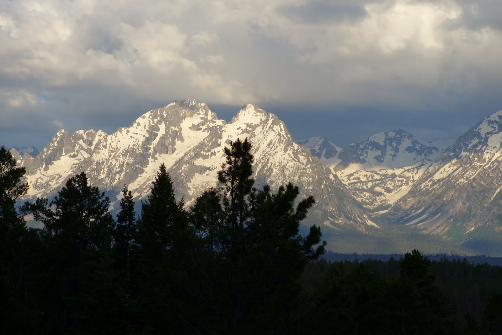
| From Jenny Lake Turn Out along river |
Up early and went to the Signal Lodge to wash up with warm water (campgrounds have all very cold water.), got a nice cup or organic coffee from the guest pot and some free ice. (Naughty me.)
Drove a little south to Jenny Lake Lodge for breakfast but all they had was guest rolls or a wonderful spread in the dining room for $23. This is a one-way road at this point for 3 more miles but a great drive along the river at the foot of the Teton Range. When I reached Moose turned right following sign to Teton Village after a little ways this became a very narrow gravel road. I wondered what kind of town I was going to visit. Turns out there are a better road directly there. However locals tell me it can be crowded and they take the back road. This back road has something to do with Rockefeller land.
This small village in the middle of nowhere is a mini Aspen wantabe. Even now they are having an art, antique show which is very elite. Met a dealer from Chicago here. All booths are high priced with exceptional wares.
So down to earth, I found a hostel in Teton Village. This will be my first bed since I have left home for $74 covering two nites. The tax here is over 14%. No full kitchen but a shower in the 4 bed dorm room. No groceries but I found supplies in the Moose Mall with mac and cheese, canned chili w/ beans, V-8, OJ, eggs and many shelves of wines.
 |
| Teton Village S'mores with friends at town square |
The town square has pop up water jets which are great for kids. Bring their bathing suits. Also a roaring gas bonfire where I gathered around 9 p.m. as one of the guys passed out so ‘mores. Sadly at 9:30 the fire went out.
Monday morning a nice shower, breakfast with my older friend (BYO) in the hostel commons downstairs. Watched the hot air balloons take off as I headed out. Headed thru Jackson Hole to the town of Jackson a little south. Civilization, I had to stop for traffic lights. This visitor’s center is definitely worth a visit: heard of stuffed deer inside with lots of displays and a viewing deck in the back. Gary at the info desk was a great help. He planned the rest of my trip thru Wyoming and into Denver. He and his wife have traveled the area for decades and knew all the best spots for looking and eating.
 |
| Jackson's Million dollar bar |
Jackson is where you fill up on gas. In Yellowstone, The Tetons and even later unleaded reg. cost around $3.99. Once you hit Jackson it is only $3.49. A must stop in Jackson is the Million Dollar Bar which is embedded with old silver dollars. And the part I like is ALL the bar stools are saddles. Swing a leg up for a drink. Want an Elk or Buffalo burger this is also the place. Another eatery highly recommended by several people is The Bunnery nice meals however the bakery goods are outstanding. Jackson does have an old West feel but bring your $$. This town square has large entry way arches of elk horns. The boy scouts collect them from an elk preserve and then sell them. I like that all the town sidewalks are wood planks. Ripley’s Believe it or Not has a place here. Good stop but unless you want to shop just a leg stretcher and stop to eat. At town’s end is a massive area for National Elk Refuge. Since it was heat of the day didn’t see any.
On ward again from Moran Jct. south to Dubois via scenic byway. Only trouble is they are blasting away parts of the mt. so a line of cars piled up to wait as the periodically blasted away. As before they have you follow a pilot car to get through. Large portions of the trees have also been cut back. : Looks like they are preparing a super HI way instead of a scenic one. After the road work area spotted a grizzly foraging off the road side.
Dubois is a nice little town. A few blocks long but with flavor. Inexpensive center on long horn sheep $2.50 with a nice, park right next to it. The must stop here is Cowboy café for good food and a large selection of homemade pies. Ate with a grandmother and granddaughter from Oregon and folks from Wisconsin.
Really tired today so after Dubois three miles turned off highway to Forest Service Road 411. Someone had suggested this area to camp. It was a gravel road which went on and on for about five miles thru valley, hills and private land posted stay on road. I was beginning to think I was misled but I kept on and finally reached Ring Lake. Noticed a camper way down below so turned down another dirt road and parked about ½ block away with a clear shot of the lake. There will be no traffic noise here, nor lights.
Up at 6 a.m. and headed right out back over the gravel road. The morning sun bouncing off the MT walls was spectacular. I am sure I stopped six times to view and photograph. On 287S/29E the buttes of layered colors jutting up, a few miles on plateaus of muted greens, a few miles more flat sagebrush land hemmed in by layers of distant mountains, then later to the left a canyon, take a turn to cross the roaring Wind River into Indian land. There wasn’t much to see on this Indian reservation. The Crow store was closed. So few autos on this road, I can stop in the middle to get my pic.
 |
| Chief Wasakie |
Traveling south take the Chief Wasakie Trail on 287S to Fort Washakie, an Indian chief who lived from 1798 – 1900 (102 yrs. Old). A right turn by Morning Star Manor takes you to his grave site which lists the wrong birth date. This same cemetery has many other interesting markers of little children, white wood crosses with no notations, and an Indian Scout. Continuing on further is the site of Sacajawea who lead Lewis and Clark to the Pacific. Two other visitors were there, the man said they keep the graves nice but not the lawn. “The lawn” was flowing with native prarie grasses. I think he expected that Indians should mow their cemetery lawns. Since the base was hard rock face they packed red dirt about two/three feet high. Some were bordered with large wood quarter rounds and then piled with the local red dirt. I wondered if like the Island Irish there were stones under the dirt.
 |
| Trout with no where to go |
After Lander is Sinks Canyon so named due to a roaring river which disappears underground and rises up in a pool later. The Rainbow trout try to swim up stream but it is just a rock wall when its rises up. Water oozing out of rock but note no water falls above.
For about 130 miles into Rawlins, Wyo nothng but sagebrush and straight ahead road. A few pronghorns is all.
 |
| Old WY State Prison - Rawlings |
Rawlings historic jail

 The best part was the pond created by a natural spring and is all clean beach sand throughout the pond. Little minors nibble at your toes which delighted the little kids. The water was just the right temperature. Close by grass area has tables, benches, shade and a rough changing area. Mill Bluff camping area also has nice playground and gazebo. I plan to stop here again when traveling that way. However may not be for every camper. Downsize: no showers but the clean swimming hole was enough; bring your own water to drinking but a well water pump is available. Only one site has electricity. Very quiet except when the trains came thru blowing their whistles across the road.